TonkaDriver
450+ Posts
Took off from home today for a 3 day trip to scout campsites for a trip in October to ride the eastern part of Arizona. We are going to ride the Coronado Trail one day and Salt River Canyon on another day. Haven't figured the third ride out yet. Grabbed a few photos from my GoPro videos of the ride between Payson and Showlow, AZ.
This is headed east out of Payson on US-260

One of the bridges spanning a creek.

This is the best stretch of the ride. In this section the highway climbs the face of the Mogollon Rim. There are spectacular views to the south all the way up.

Still climbing.

More Climbing.

Yep, Still climbing.

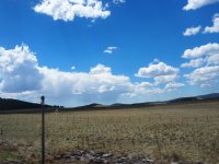
Top of the Rim.

Getting close to Showlow, AZ.

My home for the next two nights. The furniture is showing it's age but the place is clean. The a/c works the room comes with fridge, microwave and coffee maker. I like these older places because I am able to get a room where I can park by my door.

Tomorrow I will scout the area between here and Alpine to dry camp and enjoy the wilderness.
Kurt
This is headed east out of Payson on US-260
One of the bridges spanning a creek.
This is the best stretch of the ride. In this section the highway climbs the face of the Mogollon Rim. There are spectacular views to the south all the way up.
Still climbing.
More Climbing.
Yep, Still climbing.
Top of the Rim.
Getting close to Showlow, AZ.
My home for the next two nights. The furniture is showing it's age but the place is clean. The a/c works the room comes with fridge, microwave and coffee maker. I like these older places because I am able to get a room where I can park by my door.
Tomorrow I will scout the area between here and Alpine to dry camp and enjoy the wilderness.
Kurt
")